Special report
The double earthquake of June 24
Two quakes of magnitude 7.2 and 7.5, seconds apart, struck north-central Venezuela. What happened, what the maps show, what the State did and what came from abroad, with the source and date of every figure.
The figures on this page change: each one says who gives it and what day it is from. Official, UN and independent figures are never added up or averaged; they are shown side by side.
What happened
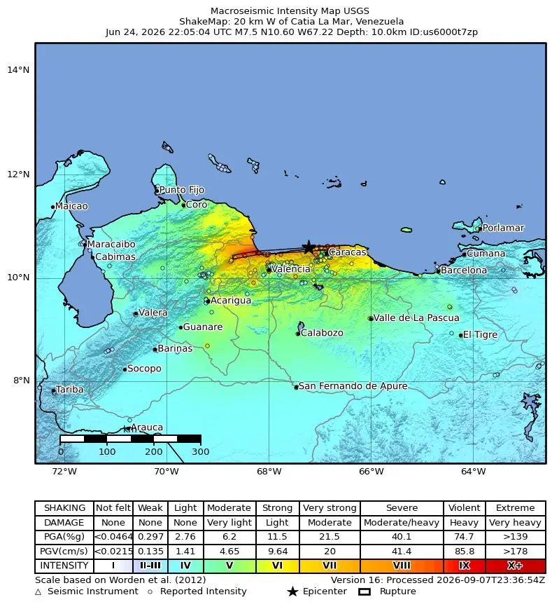
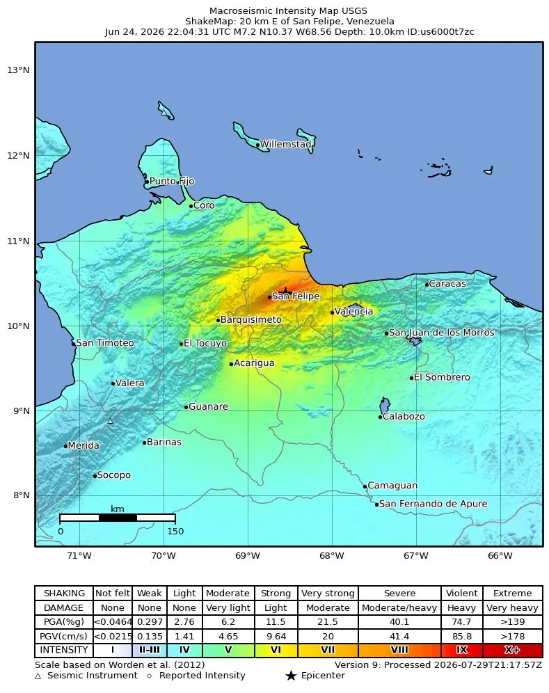
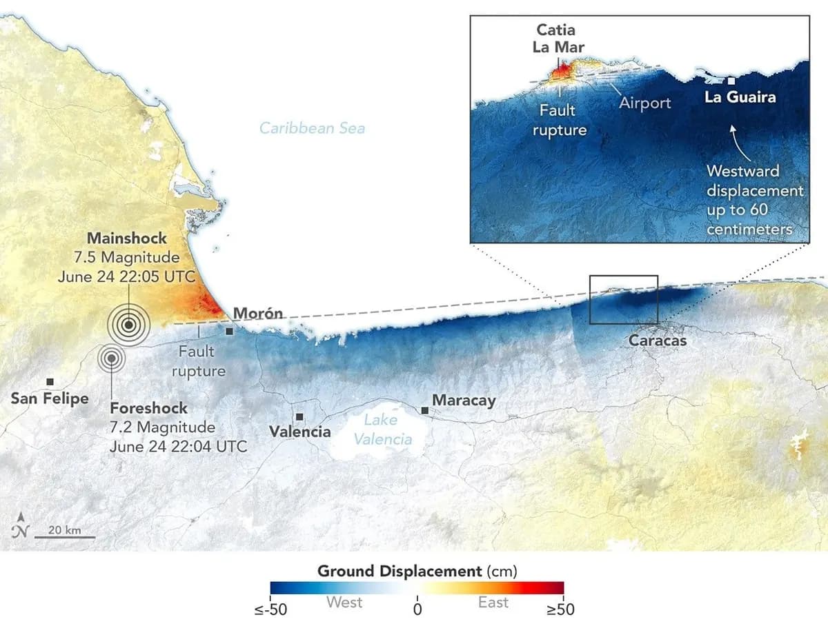
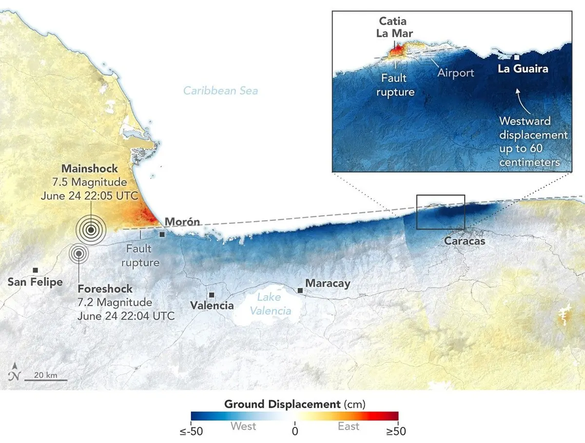
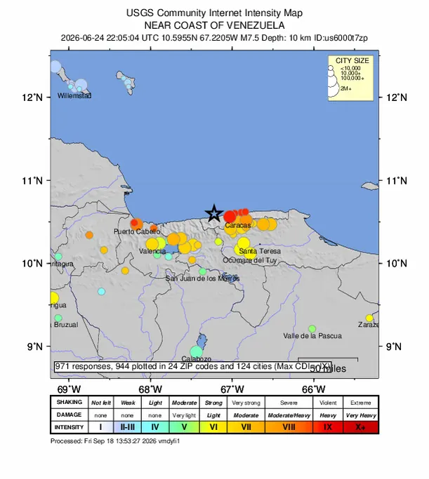
Two earthquakes, not one. On June 24, 2026, at 18:04 Venezuela time, a magnitude 7.2 quake struck about 20 km east of San Felipe (Yaracuy). Seconds later (32, according to the origin times published by the USGS) came the second, magnitude 7.5, about 20 km west of Catia La Mar (La Guaira). Both were shallow, about 10 km deep according to the USGS.[1][2]
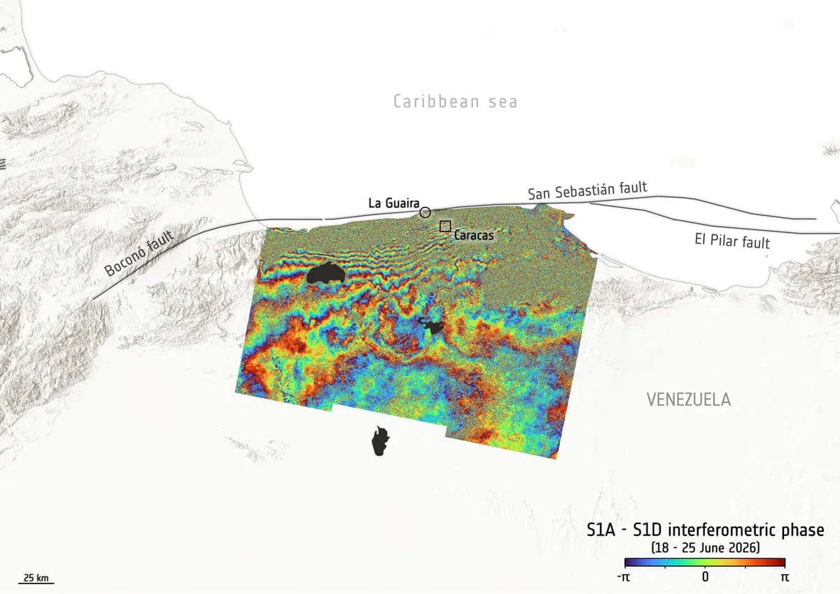
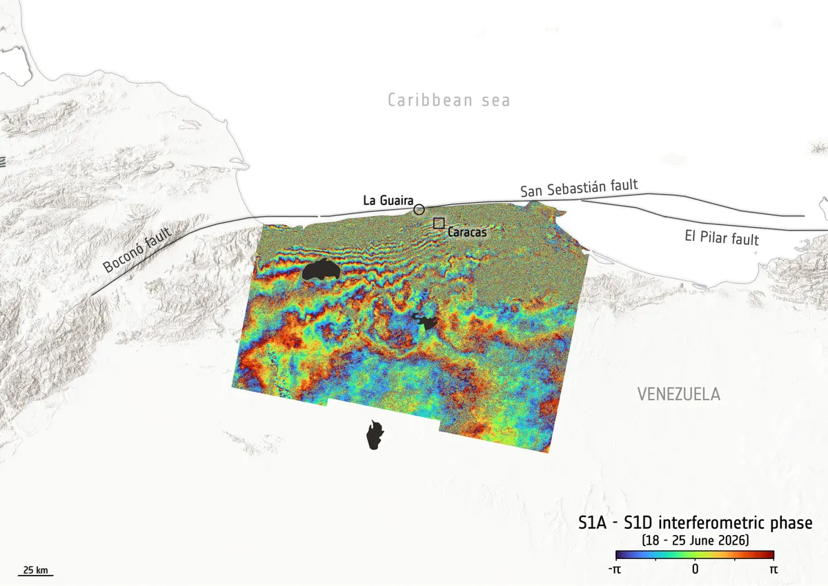
The fault. According to the USGS tectonic summary, they were right-lateral strike-slip ruptures on the San Sebastián fault system, which runs along the central coast, possibly starting at the eastern end of the Boconó fault. The rupture was about 175 km long and 20 km wide. The USGS rated both quakes red on its PAGER alert system, with a maximum intensity of IX. There was a small tsunami: 4 cm in Puerto Rico and 2 cm in Martinique.[2]
Why La Guaira was hit hardest. La Guaira lay a few kilometres from the second epicentre. Caracas Chronicles explained the damage by the combination of soft sediments, which amplify shaking, and homes built on steep slopes.[2][6]
It is still shaking. FUNVISIS counted 2,099 aftershocks and quakes between June 24 and September 24; in the week of September 18 to 24 alone there were 136, of magnitudes between 1.3 and 4. The USGS forecast issued on September 28 for the following month gives an 11% chance of an aftershock of magnitude 5 or more, 1% of one of 6 or more and less than 1% of one of 7 or more. The USGS warns that aftershocks do not get smaller over time: what drops is how often they happen.[3][4][5]
The figures
Official figure · Figure as of August 24, 2026
No new official figure in the 36 days before this review
6,509
deaths, according to the Government's latest count. The figure has not changed since.[10][11]
Official figure · Figure as of July 19, 2026
No new official figure in the 72 days before this review
16,740
injured, according to the Government. It is the same figure the UN has reported since July.[8][12]
- September 23, 2026.The 226,696 in the official count are people who received care in the hospital network (they are not injured people): they must not be read or added up as injuries.[11]
Official figure · Figure as of September 23, 2026
6,462
people rescued alive by organized teams, according to the authorities.[11]
Official figure · Figure as of June 25, 2026
No new official figure in the 96 days before this review
157
missing: the national figure given on June 25, frozen since then according to Provea.[13]
UN · Figure as of June 29, 2026
No new official figure in the 92 days before this review
50,000
missing: UN relief chief Tom Fletcher said that initial estimate remained “terrifyingly plausible”, although not all of them would be under the rubble. It is a warning, not a count.[15]
Official figure · Figure as of September 23, 2026
23,901
people live in 107 transitional camps, according to official figures cited by IOM.[11]
- September 24, 2026.El Nacional counted more than 12,000 families in tents across 28 sites in La Guaira.[16]
Official figure · Figure as of September 23, 2026
60,785
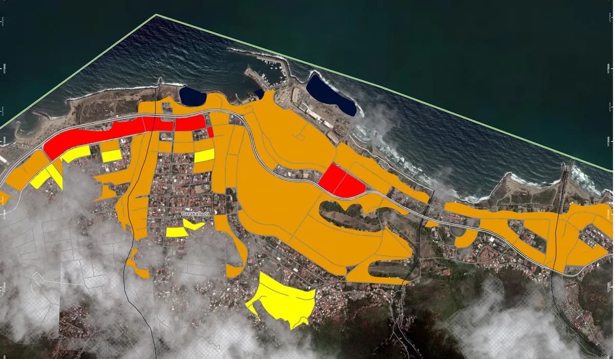
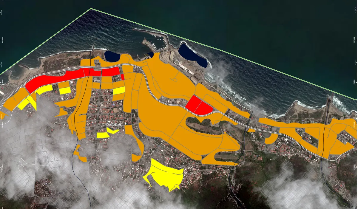
homes assessed: 35,545 habitable, 14,239 for restricted use and 11,001 at high risk, according to the authorities, as cited by IOM.[10][11]
Official figure · Figure as of August 24, 2026
No new official figure in the 36 days before this review
28.61%
of the rubble cleared: 600,790.70 tonnes of about 2.1 million, according to the authorities.[10][11]
UN · Figure as of September 18, 2026
356
health facilities assessed in La Guaira and Miranda: 216 are working, 23 were put out of action by the quakes and 117 were already out of action before June 24.[12]
Affected states
The UN counts seven affected states: La Guaira (the hardest hit), Distrito Capital, Miranda, Aragua, Carabobo, Falcón and Yaracuy. Lara is not on that list.[10]
What it cost: three estimates, three methods
Each agency used a different method: the figures are not added up or averaged.
Maps and satellite
How hard each place shook: the magnitude 7.5 quake
The first one, magnitude 7.2, near San Felipe
How far the ground moved
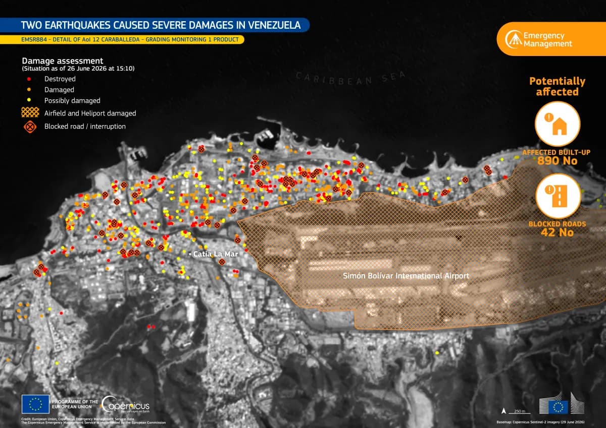
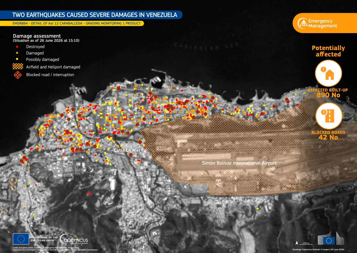
Damage in Caraballeda, area by area
Catia La Mar and the airport
European radar sees the deformation
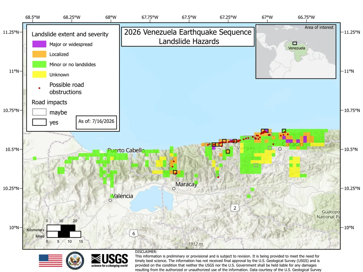
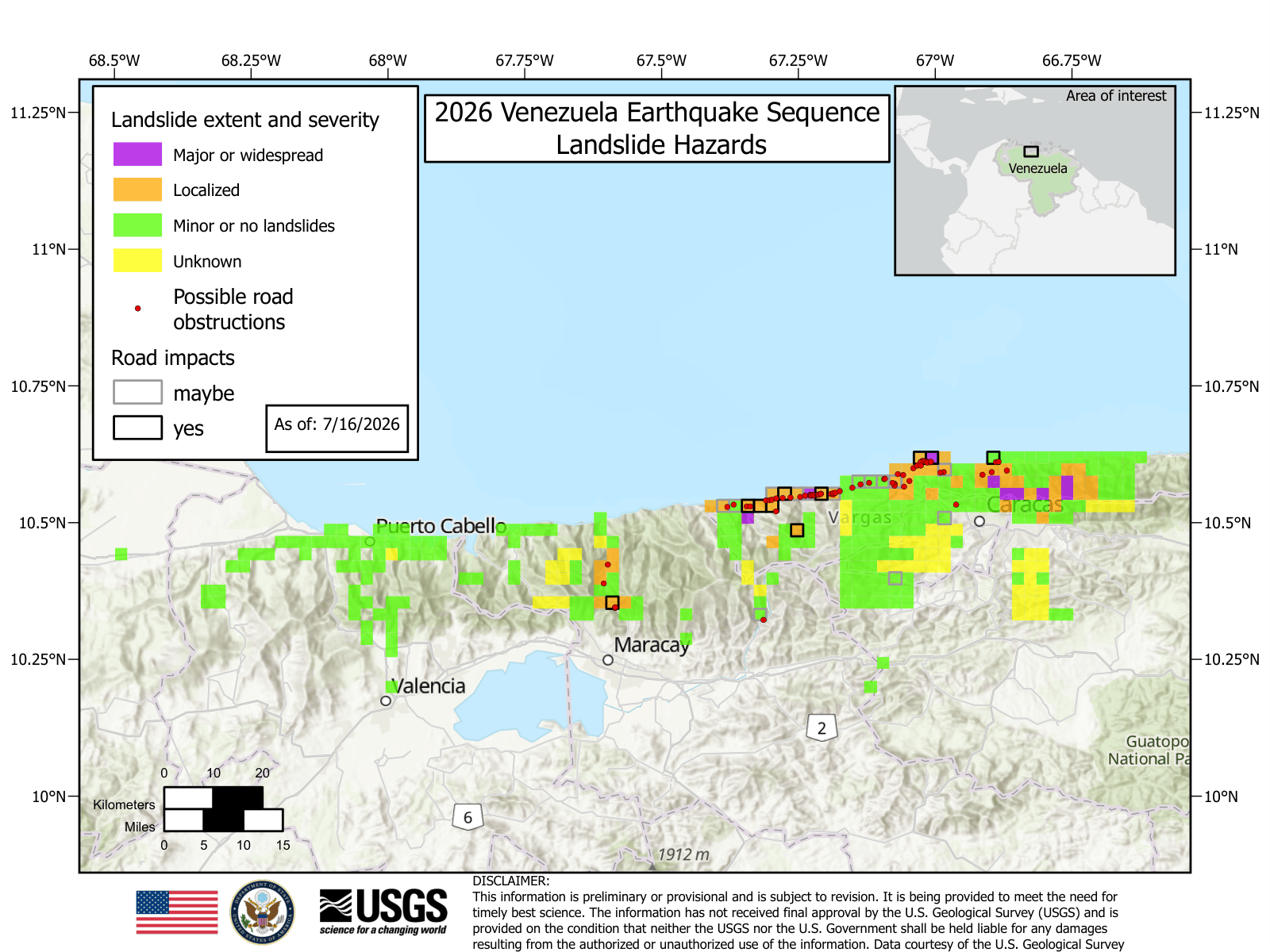
Where the hillsides came down
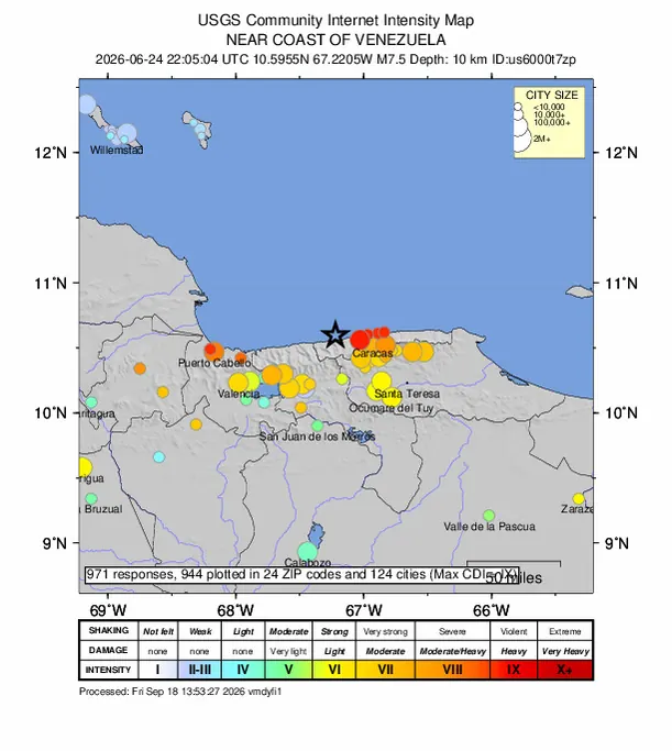
What people reported
Photos and videos
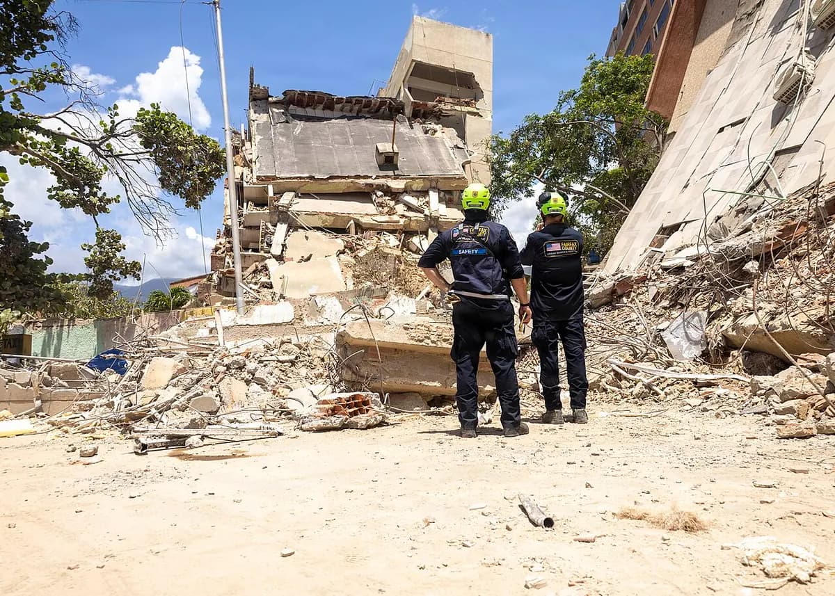
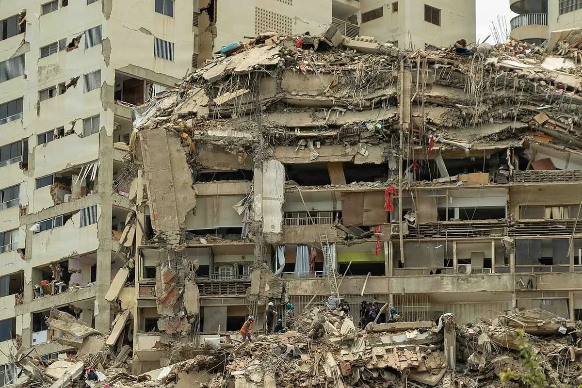
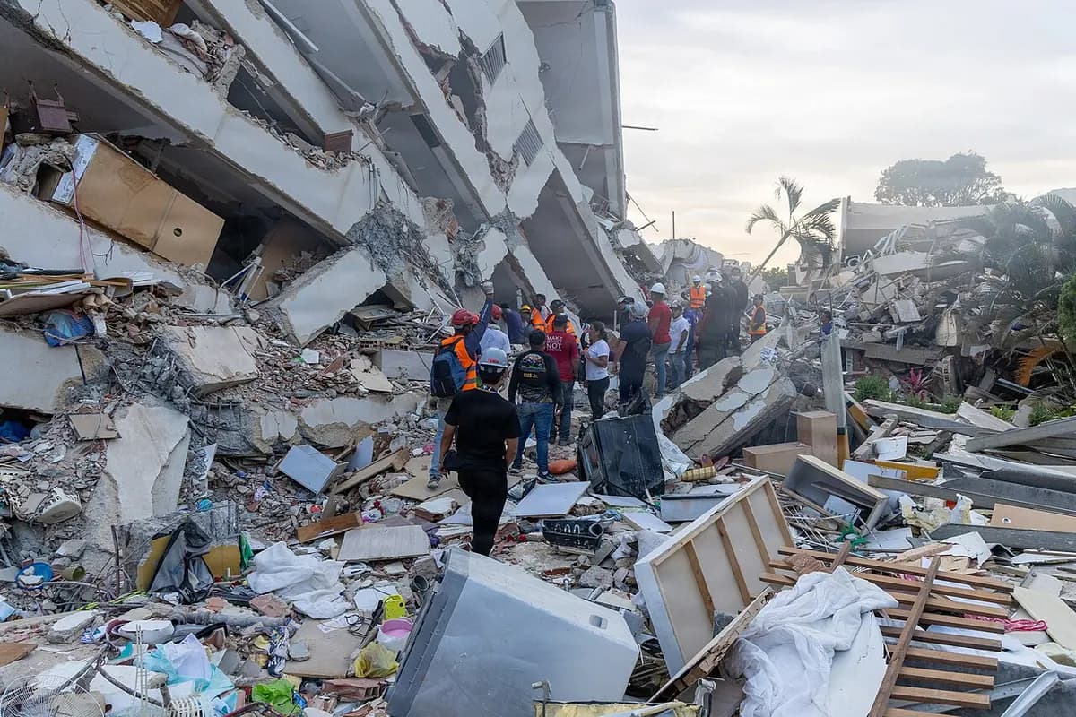
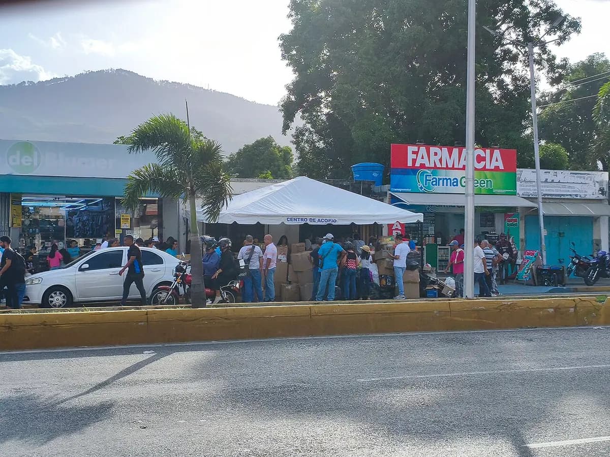
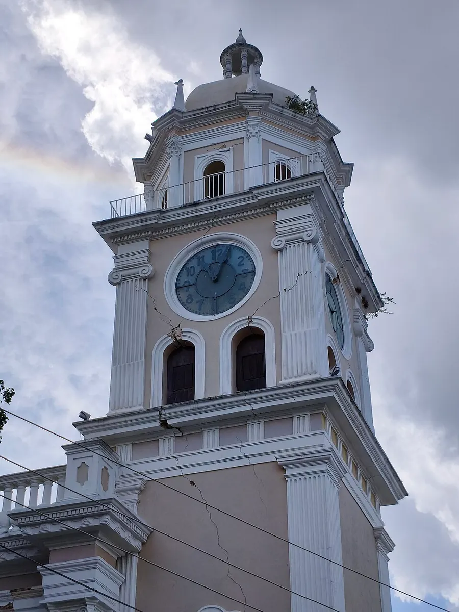
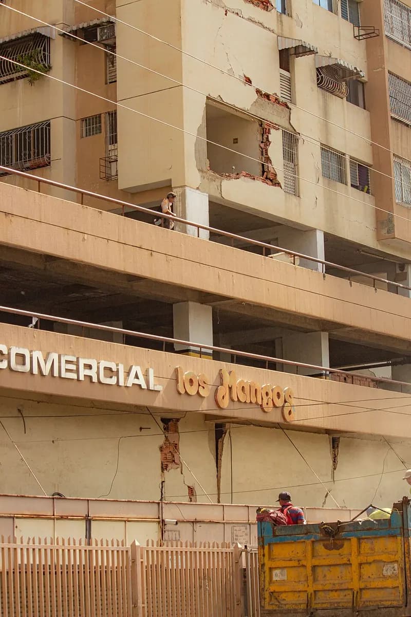
Public-domain or freely licensed photos, each with its author and licence. The captions repeat what each photo's source says. We do not publish images of victims.
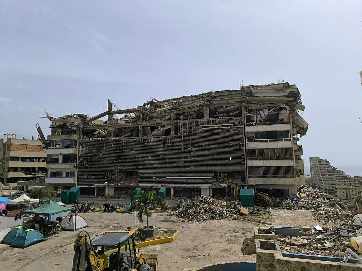

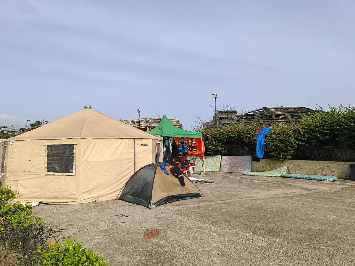

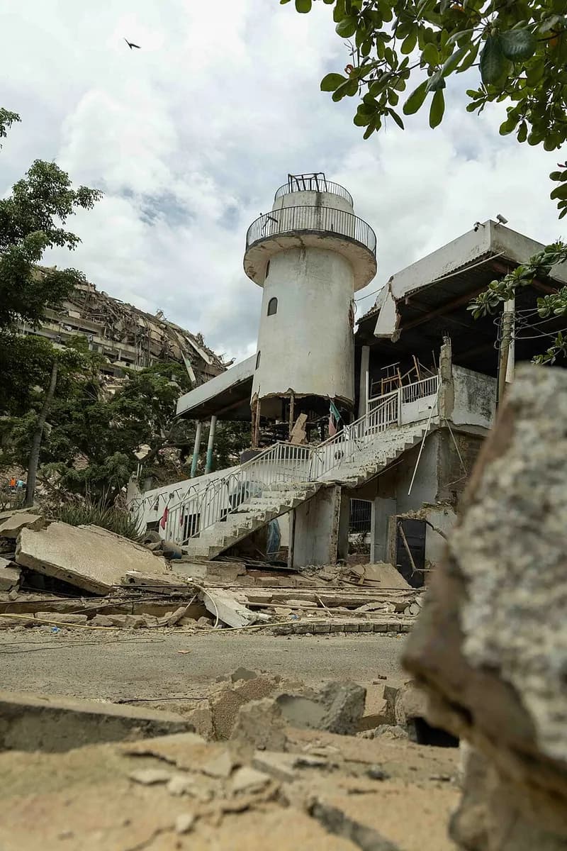
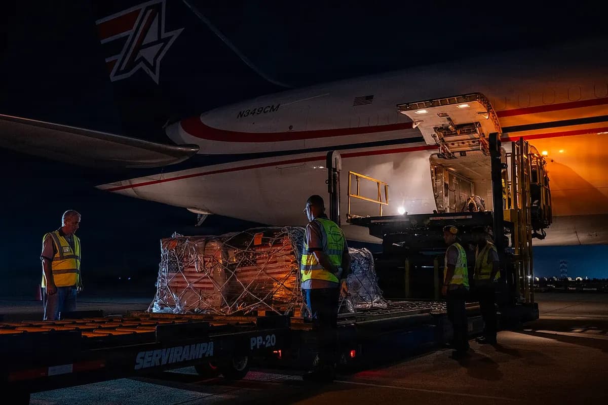



Videos
The videos are hosted on YouTube and do not load until you tap “Play”. When you play one, YouTube may collect data.
UNICEF's representative in Venezuela explains from La Guaira, on June 28, how children and families are being helped.
Watch on YouTubePress conference by the UN Population Fund (UNFPA) regional director for Latin America and the Caribbean after her mission to Venezuela.
Watch on YouTubeA Fuerza Latina (DW) report on whether aid reaches those who need it, with a food security expert.
Watch on YouTubeTechnical presentations from the Earthquake Engineering Research Institute (EERI), with the USGS and universities, on the shaking, the ground and the damage.
Watch on YouTube
Timeline
June 24, 2026
The quakes and the emergency decree
At 18:04 and 18:05 the two earthquakes strike. The Government declares a national emergency: the decree names a National Guard commander as sole authority and allows the requisition of property.[1][2][19]
June 25, 2026
157 missing, and looting
The national figure for the missing is given: 157. According to Provea, it has been frozen since then. El Nacional reports looting of damaged shops in La Guaira.[13][20]
June 26, 2026
The Government accepts foreign aid
The Government accepts international aid, including from the United States.[21]
June 27, 2026
Rescuers arrive from 27 countries
International urban search and rescue teams from 27 countries are working on the ground, according to the UN.[7]
June 29, 2026
The UN's warning
The UN relief chief says an initial estimate of 50,000 missing remains “terrifyingly plausible”.[15]
July 1, 2026
Four officers detained
The State itself announces the detention of four CICPC officers over reports that they took money from victims in the rubble.[22]
July 8, 2026
A donations platform is announced
The Government announces a platform to track donations. As of July 23 it had not appeared, according to Ruta de la Ayuda; we did not find it afterwards either.[23]
July 10, 2026
The UN asks for US$299 million
The UN adds US$299 million to its humanitarian response plan to deal with the earthquake.[8]
July 12, 2026
Transparencia Venezuela measures the response
Cut-off date of Transparencia Venezuela's gap analysis of the State's deployment in the first days.[27]
July 29, 2026
Housing subsidies from the «Venezuela Renace» fund
The Ministry of Economy and Finance announces loans and subsidies to buy homes.[24]
August 24, 2026
Last official death toll
The authorities report 6,509 deaths. It is the last number published.[10]
September 1, 2026
Maiquetía reopens, partly
The airport resumes commercial flights from temporary terminals, at about 25% of its operations. Survivors complain that moving La Guaira's property registry archives to Caracas keeps them from applying for loans.[18][25]
September 11, 2026
Where is the aid going?
Transparencia Venezuela reviews 201 announced aid actions: for at least 44% of them, it is not said where the aid goes.[28]
September 18, 2026
Early recovery
PAHO reports that the health response has moved into early recovery, while keeping emergency operations going.[12]
September 23, 2026
Amnesty International report
Three months on, Amnesty International publishes its report on the State's response.[35]
September 28, 2026
709 homes delivered
The Government says it has delivered 709 new homes and rehabilitated about 1,800. Its goal is 4,000 by the end of the year. The same day, the USGS publishes its aftershock forecast for the following month.[3][26]
The State's response
The Government accepted international aid, including from the United States, and has delivered homes, cleared rubble and reopened the airport. The documents show how much of what was announced has been done and how the emergency was handled.[18][21][26]
What was announced and what was delivered
New homes
- Announced
- 4,000 by the end of the year
Housing measures
- Announced
- 48 announcements
- Delivered or published
- Of the 47 with a known status, 9 (19%) report execution, according to Transparencia Venezuela[28]
«Venezuela Renace» fund
- Announced
- Loans and subsidies to buy homes
Platform to track donations
- Announced
- Announced in July
- Delivered or published
- Not published[23]
Number of missing people
- Announced
- 157 on June 25
What organizations and media documented
The first 48 hours. According to Transparencia Venezuela's gap analysis, at 48 hours the State had mobilized 34.6% of the force it eventually deployed, and its peak (31,837 personnel) came on day 18. 83% of the rescues by organized teams happened in those first 48 hours. Of the 19,861 people who survived, between 13,400 and 13,500 did so by getting themselves out or through local rescue.[27]
Digging by hand. Experts consulted by AP described a slow response, volunteers digging with their hands and firefighters without fuel. People interviewed by Amnesty International said the authorities' response was “late and poorly coordinated”.[33][35]
The press, by accreditation. Espacio Público documented that access to La Guaira was restricted at night, that official accreditation was required and that correspondents could only enter on official buses.[29]
Collection centres. NTN24 aired a video in which police officers say that “only the mayor's office and the PSUV are authorized” to receive donations, and reported that collection centres of an opposition party were dismantled. Emol and The Washington Post gathered complaints from rescuers and volunteers who were prevented from working or delivering aid.[30][31][32]
Rights. The Human Rights Observatory of the University of Los Andes counted at least seven rights violated, including restrictions on aid brigades, censorship and blocking of NGO websites, as cited by Ruta de la Ayuda.[34]
Shelters and NGOs. Amnesty International documented that permission to work in shelters depended on each organization's relationship with the authorities, and that the law regulating NGOs limited their ability to help. The New Humanitarian reported customs delays and orders to halt aid programmes.[35][36]
What we could not confirm
Some claims are circulating that we found no documents to support. We list them so they are not repeated as fact.
- It is not true that the Government turned down international aid: it accepted it, including from the United States.[21]
- We found no evidence that aid was made conditional on the Carnet de la Patria (the government's Homeland Card). The Patria system was used to register people and pay allowances; what is documented is control of collection centres by the mayor's office and the ruling party.[30][40]
- We found no documented evidence that aid was stolen or diverted. Transparencia Venezuela documents a lack of accountability: for at least 44% of the announced actions, it is not said where the aid goes.[28]
- It is not true that nothing was delivered: homes have been handed over and aid has been verified, although far short of what was announced.[26][41]
Who took advantage
Reported price hikes
September 21, 2026
The La Guaira Real Estate Chamber reported rising purchase and rental prices for homes in the hardest-hit areas, and gave as an example a property that cost US$70,000 before June 24 and is now offered at US$150,000. The ceiling on loans for quake victims is US$100,000.[37][38]
Officers detained
July 1, 2026
The State announced the detention of four CICPC officers over reports that they stole money from victims in the rubble.[22]
Looting
June 25, 2026
El Nacional reported looting of shops damaged by the earthquakes in La Guaira.[20]
Fake bonuses
July 2, 2026
Announcements of “bonuses” for quake victims circulated on Facebook and on an unofficial Telegram channel, with amounts the Patria system had not published. Bloomberg Línea verified they were false.[40]
Donation scams
July 8, 2026
The New York Attorney General warned about donation scams for Venezuela and explained how to give safely. We found no documented count of scams inside the country.[39]
International aid
Ruta de la Ayuda, Transparencia Venezuela's tracker, records every pledge announced by governments, agencies, companies and individuals, and follows it until it is delivered. According to that tracker, only 21 of the 48 donor governments report their aid to the UN's financial tracking service.[41]
The United States pledged more than US$300 million, channelled through Caritas and Catholic Relief Services, the World Food Programme, UNICEF, IOM and the UN pooled fund, without going through the Venezuelan State.[34][41]
The UN asked for an additional US$299 million for the earthquake, bringing its 2026 humanitarian plan to US$931 million; as of August 27 it was 43.1% funded, according to OCHA. The International Federation of Red Cross and Red Crescent Societies launched an appeal for 50 million Swiss francs.[10][17]
Aid announced, according to Ruta de la Ayuda
- announced in total
- US$1,357.7 million
- pledges from 154 donors
- 155
Where each pledge stands
Delivered and verified57
In transit or partly delivered37
Announced only49
Other statuses (partial deliveries or pending confirmation)12
Data: Ruta de la Ayuda — Transparencia Venezuela, CC BY 4.0 license. Cut-off September 25, 2026; retrieved September 29, 2026.[41]
What about Lara?
Felt strongly, no damage reported. On the night of June 24, Protección Civil Lara reported that no deaths, injuries or infrastructure damage had been recorded in the state that day; it was a first assessment, made hours after the quakes. It also carried out controlled evacuations of vulnerable buildings. Lara is not among the affected states in UN reports.[10][42]
How hard it shook here. According to the USGS ShakeMap model, the first quake, the magnitude 7.2, produced an estimated intensity of VI in Barquisimeto and Cabudare (strong, light damage possible); the second, the 7.5, of V (moderate). These are model estimates, not measurements on every street.[1][2][54]
We live on a fault. Barquisimeto and Cabudare are crossed by branches of the Boconó fault, and the sediments of the Turbio valley amplify shaking. The seismic microzoning of both cities, carried out between 2005 and 2009, studied how the ground responds in each area.[43]
It has happened before. On March 26, 1812, an earthquake of estimated magnitude 7.1 destroyed Barquisimeto, killing about 1,000 people. El Tocuyo suffered quakes of estimated magnitude 6.8 in 1674 and 6 in 1870, and in 1894 there was another of magnitude 7.[44]
El Tocuyo, 1950: two figures. The August 3, 1950 quake in El Tocuyo, of estimated magnitude between 6.3 and 6.9, left 17 dead and 80 injured according to La Prensa de Lara; FUNVISIS gives 8 dead, 60 injured and 250 houses destroyed. Both figures are published; we do not know which is correct.[44][45]
Building right. Venezuela's current seismic building code is COVENIN 1756-1:2019. Experts cited by AP blamed part of June's damage on old buildings and poor construction.[46][47]
Sources
- 1.U.S. Geological Survey (USGS), M 7.2 – 20 km E of San Felipe, Venezuela (Jun 24, 2026).
- 2.U.S. Geological Survey (USGS), M 7.5 – 20 km W of Catia La Mar, Venezuela (tectonic summary updated on August 7) (Jun 24, 2026).
- 3.U.S. Geological Survey (USGS), Aftershock Forecast — M 7.5 Venezuela (Sep 28, 2026).
- 4.U.S. Geological Survey (USGS), Aftershock Forecast Overview.
- 5.El Diario, Funvisis reporta 2.099 sismos en Venezuela desde el 24 de junio (Sep 27, 2026).
- 6.Caracas Chronicles, Why Were the June 24 Earthquakes So Destructive? (Jun 25, 2026).
- 7.OCHA, Earthquakes in Venezuela: Situation Report No. 4 (Jun 27, 2026).
- 8.OCHA, Earthquakes in Venezuela: Situation Report #26 (Jul 19, 2026).
- 9.EFE vía El Diario, El Banco Mundial calcula en 19,6 millardos de dólares los daños por el doble terremoto en Venezuela (Jul 23, 2026).
- 10.OCHA, Earthquakes in Venezuela: Situation Report #34 (Aug 27, 2026).
- 11.OIM (vía ReliefWeb), Venezuela (Bolivarian Republic of): Earthquake Response Situation Report #30 (17 to 23 September 2026) (Sep 23, 2026).
- 12.OPS/OMS, Situation Report No.11: Earthquakes in Venezuela 2026 (M7.2 and M7.5) (Sep 18, 2026).
- 13.El Diario, Provea alertó que falta de transparencia estatal vulnera derechos fundamentales tras los terremotos (Aug 3, 2026).
- 14.Runrun.es, Revelan cifra de desaparecidos en terremotos de La Guaira: Gobernador dice que son 1579 (Aug 4, 2026).
- 15.Noticias ONU, Venezuela quake: Search goes on for survivors amid ‘impossible odds’ (Jun 29, 2026).
- 16.El Nacional, Damnificados de La Guaira sobreviven entre carpas y promesas a tres meses de los terremotos (Sep 24, 2026).
- 17.IFRC, Venezuela: Earthquake 2026 (llamamiento de emergencia).
- 18.DW, Aeropuerto de Caracas reabre tras graves daños por sismos (Sep 1, 2026).
- 19.Banca y Negocios, Lo que debes saber sobre el Decreto de Emergencia Nacional por los terremotos en Venezuela (Jun 27, 2026).
- 20.El Nacional, Reportan saqueos en comercios afectados por los terremotos en La Guaira (Jun 25, 2026).
- 21.CNN en Español, La Venezuela de Delcy Rodríguez está tan golpeada que la presidenta no puede rechazar la ayuda ni de amigos ni de enemigos (Jun 26, 2026).
- 22.El Diario, CICPC detuvo a cuatro agentes tras denuncias de robo de dinero de víctimas de los terremotos en La Guaira (Jul 1, 2026).
- 23.Ruta de la Ayuda (Transparencia Venezuela), Un mes después, la «plataforma» de Delcy Rodríguez sigue sin aparecer (Jul 23, 2026).
- 24.Ministerio del Poder Popular de Economía y Finanzas (MPPEF), Anuncian plan crediticio y subsidios del Fondo «Venezuela Renace» para la compra de vivienda tras el doblete sísmico (Jul 29, 2026).
- 25.Infobae, Venezuela: damnificados por terremotos denuncian trabas para solicitar créditos hipotecarios (Sep 1, 2026).
- 26.EFE vía Infobae, Más de 700 viviendas entregadas a afectados por terremotos en Venezuela, dice Gobierno (Sep 28, 2026).
- 27.Transparencia Venezuela (Ruta de la Ayuda), La insuficiente respuesta estatal: el desastre ocurrió antes del doble terremoto (corte del 12 de julio) (Jul 12, 2026).
- 28.Transparencia Venezuela, A más de dos meses después de los terremotos, escasea la rendición de cuentas de la ayuda humanitaria (Sep 11, 2026).
- 29.Espacio Público, Libertad de expresión durante la emergencia por los terremotos en Venezuela 24 al 28 de junio de 2026 (Jul 2, 2026).
- 30.NTN24, Denuncian que funcionarios del régimen venezolano están impidiendo ayudas en medio de la tragedia que enluta al país (Jun 25, 2026).
- 31.Emol, Las denuncias contra el Gobierno venezolano de impedir las labores de rescate y entrega de ayuda tras doble terremoto (Jun 30, 2026).
- 32.The Washington Post, After quakes trap Venezuelans, the government impedes rescuers and aid (Jul 1, 2026).
- 33.AP vía PBS NewsHour, In Venezuela, a ‘completely ineffective’ government worsens earthquake disaster, experts say (Jul 2, 2026).
- 34.Ruta de la Ayuda (Transparencia Venezuela), La ayuda que llega por fuera del Estado (Aug 3, 2026).
- 35.Amnistía Internacional, Venezuela: A tres meses del doble terremoto sigue ausente una respuesta centrada en derechos humanos (Sep 23, 2026).
- 36.The New Humanitarian, Venezuela in-depth: Attention fades even as earthquake needs spiral (Jul 28, 2026).
- 37.El Nacional, Denuncian aumentos de precios de alquiler y compra de inmuebles en La Guaira (Sep 21, 2026).
- 38.Descifrado, Aumentan precios de inmuebles en La Guaira por captación de subsidios de vivienda (Sep 22, 2026).
- 39.El Diario NY, Fiscal General de Nueva York alerta sobre estafas tras el terremoto en Venezuela y explica cómo donar de forma segura (Jul 8, 2026).
- 40.Bloomberg Línea, Bono por terremoto en Venezuela 2026: qué sí anunció el Sistema Patria y qué es falso (Jul 2, 2026).
- 41.Ruta de la Ayuda — Transparencia Venezuela (datos CC BY 4.0), Ruta de la Ayuda: registro de compromisos de ayuda internacional (corte del 25 de septiembre) (Sep 25, 2026).
- 42.El Impulso, Protección Civil Lara desplegada tras fuerte sismo: no se reportan daños materiales ni víctimas en la entidad (Jun 24, 2026).
- 43.Schmitz y otros, revista GEOMINAS vol. 48, n.º 81, Resultados e implementación de la microzonificación sísmica de Barquisimeto y Cabudare, Venezuela (Apr 2020).
- 44.La Prensa de Lara, Se cumplen 76 años del último gran terremoto en Lara (Aug 3, 2026).
- 45.FUNVISIS, El drama tocuyano del sismo de 1950.
- 46.GEM Foundation, Seismic regulations: Venezuela (COVENIN 1756-1:2019).
- 47.AP vía El Buen Día, Edificios antiguos y construcción deficiente hicieron a Venezuela vulnerable a terremotos (Jun 27, 2026).
- 48.NASA Earth Observatory, Where Venezuela’s Earthquakes Shifted the Ground (Jul 10, 2026).
- 49.Copernicus Emergency Management Service, EMSR884: Earthquake in Venezuela — AOI12 Caraballeda, grading product v2 (Jun 27, 2026).
- 50.EU Space (EUSPA), Two earthquakes leave severe damage across northern Venezuela (Jul 2, 2026).
- 51.Agencia Espacial Europea (ESA), Sentinel-1 shows ground displacement after Venezuela earthquakes.
- 52.USGS Landslide Hazards Program, 2026 Venezuela Earthquake Sequence: Landslide Hazards (al 16 de julio) (Jul 16, 2026).
- 53.U.S. Geological Survey (USGS), Did You Feel It? — M 7.5 Venezuela.
- 54.U.S. Geological Survey (USGS), ShakeMap — M 7.5 y M 7.2 Venezuela (intensidad estimada por lugar).